


Another AR cloud savior has emerged this week in Fantasmo, a startup that wants to turn anyone with a smartphone into a cartographer for spatial maps.
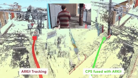
The company's camera positioning standard (CPS) captures spatial data through your device's camera. With this data stored in a server, AR apps can readily and accurately determine position and location relative to recognized landmarks in the immediate vicinity.
If that sounds familiar, it's because Niantic has proposed a similar model, with players of its location-based AR games collecting spatial data while they capture Pokémon monsters and such. Fantasmo's approach also mirrors another startup, 6D.ai, whose platform can capture a dense 3D mesh with smartphone cameras while running in the background.
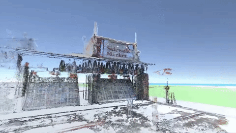
Fantasmo, however, has its sights set not just on the world and its structures; it wants to build 3D maps of indoors spaces as well. When easily accessible to all, this data enables 3D content that can move over distances without floating above the ground or disappearing behind walls when such structures get in the way. The company also believes these 3D maps can be applied to real world navigation for robots.
"The most important dataset that will be built in the coming decade is the sub-centimeter 3D map of the world, indoors and out. It will provide a foundation for the next generation of human experiences, in which software will be able to program devices to interact meaningfully with the physical world around them," wrote Jameson Detweiler, co-founder and CEO of Fantasmo in a blog post. "We need an open infrastructure for 3D spatial data to break out of these silos and unlock the potential of the next era of maps."
That's a tall task, considering the privacy implications of allowing open access to maps of private property. Detweiler not only acknowledges this, but also proposes protocols that would allow data to be easily shared and accessed between apps and devices while standardizing permissions so that property owners can maintain control of spatial data of their spaces.
"The only fair and scalable approach to private indoor data is to empower property owners and their tenants to control who has access and how it is used," he writes. "The only fair approach to public, outdoor spaces is to make it free and available for everyone."
In addition to the CPS platform, Fantasmo will release, over the coming months, an open source toolkit for spatial mapping devices, a storage system for shared maps, and a network for sharing spatial data between users.
Interested parties, such as developers, property owners, or anyone who wants to help map the world in AR, can sign up for more information at the company's website.
- Follow Next Reality on Facebook, Twitter, Instagram, YouTube, and Flipboard
- Sign up for our new Next Reality newsletter
- Follow WonderHowTo on Facebook, Twitter, Pinterest, and Flipboard
Cover image via Fantasmo


Comments
Be the first, drop a comment!